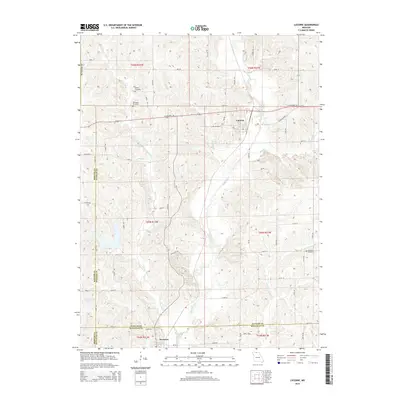
2014 Map of Lucerne
USGS Topo · Published 2014About this map
Lucerne and Newtown anchor this 2014 survey of the borderlands where Putnam, Sullivan, and Mercer Counties meet. The landscape is defined by the dendritic drainage patterns of Medicine Cr and Barber Cr, which flow south toward the Sullivan County line. This region in northern Missouri retains a strictly rural character, with the township and range grid (including T66N R21W and T65N R22W) dictating the placement of modern routes like US Highway 136 and State Highway A. Local history is preserved in small family and community burial grounds, such as the Busby Cemetery and the nearby Old Busby Cemetery north of Lucerne. To the southeast, near the winding Little W Locust Cr, the Howard Cemetery remains as a landmark of earlier settlement. The map captures the persistent intersection of pioneer-era burial sites and the established agricultural road network of the early 21st century.
Find a feature on this map
40 named features on this map. Tap any name to fly to it.
Don’t see what you’re looking for? This feature index may not catch every label — zoom into the map to look around manually.
Map Details
Editions of this 2014 Lucerne Map
This is the sole edition of this map. No revisions or reprints were ever made.
Other maps of this area

1942 · Seymour
USGS Topo · 1:62,500

1944 · Seymour
USGS Topo · 1:62,500

1954 · Centerville
USGS Topo · 1:250,000

1957 · Centerville
USGS Topo · 1:250,000

1958 · Centerville
USGS Topo · 1:250,000

1964 · Pollock NW
USGS Topo · 1:24,000

1964 · Ravanna
USGS Topo · 1:24,000

1964 · Harris
USGS Topo · 1:24,000

1964 · Half Rock
USGS Topo · 1:24,000
1964 · Pollock SW
USGS Topo · 1:24,000