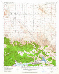
1947 Map of Lucerne Valley
USGS Topo · Published 1964About this map
Big Bear Lake and the high country of the San Bernardino National Forest dominate the southern half of this landscape, transitioning sharply into the Mojave Desert to the north. Surveyed in the late 1940s, the map documents a region defined by its extractive history and early mountain tourism. The area around Holcomb Valley and Gold Mtn is peppered with evidence of the nineteenth-century gold rush, including the Doble Mine (Aband) and the settlement of Doble near Baldwin Lake. To the north, the arid expanse around Lucerne Dry Lake shows a sparser settlement pattern centered on the Lucerne Valley post office and rural landmarks like the Midway Sch and Box S Ranch. The contrast between the timbered slopes around Fawnskin and the stark northern buttes, such as Negro Butte, illustrates the dramatic topographical shift from the San Bernardino Mountains to the desert floor.
Find a feature on this map
79 named features on this map. Tap any name to fly to it.
Don’t see what you’re looking for? This feature index may not catch every label — zoom into the map to look around manually.
Map Details
Editions of this 1947 Lucerne Valley Map
5 editions found
Other maps of this area

1899 · Redlands
USGS Topo · 1:62,500

1901 · Southern California Sheet No. 1
USGS Topo · 1:250,000

1901 · Redlands
USGS Topo · 1:62,500

1902 · Deep Creek
USGS Topo · 1:62,500

1902 · San Gorgonio
USGS Topo · 1:125,000

1904 · Southern California Sheet No. 1
USGS Topo · 1:250,000

1932 · Barstow
USGS Topo · 1:125,000

1934 · Barstow
USGS Topo · 1:125,000

1947 · Lucerne Valley
USGS Topo · 1:62,500

1949 · Lucerne Valley
USGS Topo · 1:62,500