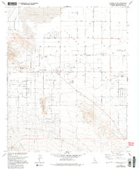
1971 Map of Lucerne Valley
USGS Topo · Published 1994About this map
Lucerne Valley is centered in this High Desert landscape, appearing as a hub of rural development in the early 1970s. The settlement pattern is defined by a grid of named streets such as Agate Road and Carnelian Road, alongside specialized facilities like the Fire Control Station and Substation. The topography is dominated by the dry expanse of Lucerne Lake to the north and the sharp rises of the Granite Mts and Strawberry Peak to the west. Evidence of local water sources is vital in this arid environment, marked by Rabbit Springs and the remote Box S Springs near the southern boundary. Industrial activity is visible through scattered Gravel Pits and a Mine, while civic life is anchored by Lucerne Valley Park and Pioneer Park.
Find a feature on this map
47 named features on this map. Tap any name to fly to it.
Don’t see what you’re looking for? This feature index may not catch every label — zoom into the map to look around manually.
Map Details
Editions of this 1971 Lucerne Valley Map
3 editions found
Other maps of this area

1901 · Southern California Sheet No. 1
USGS Topo · 1:250,000

1902 · Deep Creek
USGS Topo · 1:62,500

1902 · San Gorgonio
USGS Topo · 1:125,000

1904 · Southern California Sheet No. 1
USGS Topo · 1:250,000

1932 · Barstow
USGS Topo · 1:125,000

1934 · Barstow
USGS Topo · 1:125,000

1947 · Lucerne Valley
USGS Topo · 1:62,500

1949 · Lucerne Valley
USGS Topo · 1:62,500

1953 · San Bernardino
USGS Topo · 1:250,000

1955 · Ord Mountains
USGS Topo · 1:62,500