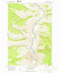
1963 Map of Lucile
USGS Topo · Published 1979About this map
The Salmon River carves a deep path through this portion of the Nez Perce National Forest, where the small settlement of Lucile sits on the riverbanks. This 1963 field-checked survey reveals a landscape defined by riverside bars and high ridges, punctuated by signs of early mining and habitation. Historical memory is anchored by the Chief Joseph War Historical Marker and the nearby Lucile Caves. A network of primitive transit, including the Walker Road and Sherwin Trail, connects isolated points like the Thompson Place to the river valley. The map documents the local infrastructure of the era, such as the Cow Creek Sch and a riverside Cem, alongside industrial efforts at the McKinley Mine. Distinctive river features like Box Canyon and Blackhawk Bar illustrate the complex geography that shaped Idaho's canyon-country history.
Find a feature on this map
47 named features on this map. Tap any name to fly to it.
Don’t see what you’re looking for? This feature index may not catch every label — zoom into the map to look around manually.
Map Details
Editions of this 1963 Lucile Map
2 editions found
Other maps of this area

1938 · Riggins
USGS Topo · 1:96,000

1945 · Riggins
USGS Topo · 1:125,000

1955 · Grangeville
USGS Topo · 1:250,000

1959 · Grangeville
USGS Topo · 1:250,000

1963 · John Day Mtn
USGS Topo · 1:24,000

1963 · Lucile
USGS Topo · 1:24,000

1963 · McKinzie Creek
USGS Topo · 1:24,000

1963 · Slate Creek
USGS Topo · 1:24,000

1963 · Kirkwood Creek
USGS Topo · 1:24,000

1963 · Grave Point
USGS Topo · 1:24,000