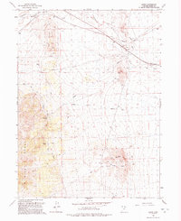
1992 Map of Lucin
USGS Topo · Published 1992About this map
Lucin stands as a focal point in the Great Salt Lake Desert, where the historic Southern Pacific tracks meet the innovative Lucin Cutoff. This 1990s record captures a landscape defined by its transit history, showing the Old Railroad Grade winding through a terrain of scattered water sources like Coal Bank Springs and Indian Spring. The map documents essential infrastructure for this arid region, including an extensive Aqueduct system and several water tanks.
Find a feature on this map
22 named features on this map. Tap any name to fly to it.
Don’t see what you’re looking for? This feature index may not catch every label — zoom into the map to look around manually.
Map Details
Editions of this 1992 Lucin Map
This is the sole edition of this map. No revisions or reprints were ever made.
Other maps of this area

1954 · Brigham City
USGS Topo · 1:250,000

1955 · Wells
USGS Topo · 1:250,000

1958 · Wells
USGS Topo · 1:250,000

1958 · Brigham City
USGS Topo · 1:250,000

1961 · Wells
USGS Topo · 1:250,000

1962 · Brigham City
USGS Topo · 1:250,000

1967 · Jackson Spring
USGS Topo · 1:24,000

1967 · Pigeon Mountain
USGS Topo · 1:24,000

1967 · Lucin
USGS Topo · 1:24,000

1967 · Patterson Pass
USGS Topo · 1:24,000