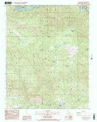
1987 Map of Luckett Mtn
USGS Topo · Published 1987About this map
Pine Flat Lake and the Kings River define the northern reaches of this territory, where the steep canyons of the Sierra National Forest meet the southern boundaries of the Sequoia National Forest. The landscape is dominated by significant elevations such as Oat Mountain and the central summit of Luckett Mtn, providing a look at the rugged topography before the modern expansion of forest management facilities.
Find a feature on this map
26 named features on this map. Tap any name to fly to it.
Don’t see what you’re looking for? This feature index may not catch every label — zoom into the map to look around manually.
Map Details
Editions of this 1987 Luckett Mtn Map
3 editions found
Other maps of this area

1921 · Squaw Valley
USGS Topo · 1:31,680

1922 · Trimmer
USGS Topo · 1:96,000

1924 · Citrus Cove
USGS Topo · 1:31,680

1924 · Dinuba
USGS Topo · 1:125,000

1942 · Watts Valley
USGS Topo · 1:62,500

1942 · Dunlap
USGS Topo · 1:62,500

1944 · Watts Valley
USGS Topo · 1:62,500

1944 · Dunlap
USGS Topo · 1:62,500

1948 · Fresno
USGS Topo · 1:250,000
1950 · Orange Cove North
USGS Topo · 1:24,000