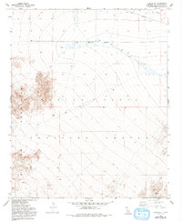
1954 Map of Ludlow SE
USGS Topo · Published 1993About this map
The Bullion Mountains dominate this high desert landscape, which was primarily defined by military use in the mid-1950s. The terrain is marked by a sweeping network of desert washes that drain from the higher elevations down toward the Naval Reservation Boundary. This specific area reflects a transition in land use within San Bernardino County, as vast stretches were designated as the Marine Corps Training Center. Aside from a utility Pipeline crossing the northern boundary, there is almost no civilian infrastructure present, highlighting the area's isolation and its specific role in national defense and training during the Cold War era.
Find a feature on this map
8 named features on this map. Tap any name to fly to it.
Don’t see what you’re looking for? This feature index may not catch every label — zoom into the map to look around manually.
Map Details
Editions of this 1954 Ludlow SE Map
4 editions found
Other maps of this area

1942 · Amboy
USGS Topo · 1:250,000

1943 · Amboy
USGS Topo · 1:250,000

1953 · San Bernardino
USGS Topo · 1:250,000

1954 · Needles
USGS Topo · 1:250,000

1954 · Bagdad SW
USGS Topo · 1:24,000

1954 · Ludlow SE
USGS Topo · 1:24,000

1955 · Deadman Lake NW
USGS Topo · 1:24,000

1955 · Ludlow
USGS Topo · 1:24,000

1955 · Morgans Well
USGS Topo · 1:24,000

1955 · Lead Mountain
USGS Topo · 1:24,000