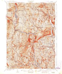
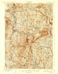
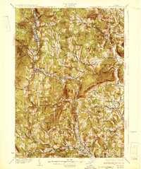
1932 Map of Ludlow
USGS Topo · Published 1938About this map
The Black River carves a deep path through these Vermont hills, anchoring a string of mill towns and manufacturing villages connected by the Rutland RR. This depression-era survey details the dense industrial and agricultural settlement patterns of the late 1920s, featuring prominent sites like Ludlow, Proctorsville, and Cavendish. The river's power is evident at Cavendish Gorge, while the surrounding terrain is dominated by the massive ridge of Hawks Mountain.
Find a feature on this map
128 named features on this map. Tap any name to fly to it.
Don’t see what you’re looking for? This feature index may not catch every label — zoom into the map to look around manually.
Map Details
Editions of this 1932 Ludlow Map
4 editions found

Other maps of this area

1891 · Rutland
USGS Topo · 1:62,500

1893 · Wallingford
USGS Topo · 1:62,500

1893 · Rutland
USGS Topo · 1:62,500

1894 · Londonderry
USGS Topo · 1:62,500

1899 · Londonderry
USGS Topo · 1:62,500

1906 · Hanover
USGS Topo · 1:62,500

1908 · Hanover
USGS Topo · 1:62,500

1911 · Woodstock
USGS Topo · 1:62,500

1913 · Woodstock
USGS Topo · 1:62,500

1926 · Claremont
USGS Topo · 1:62,500