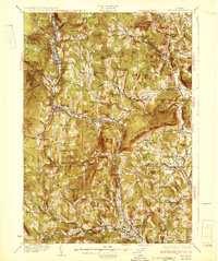
1932 Map of Ludlow
USGS Topo · Published 1932About this map
The Rutland Railroad winds through the heart of the Black River valley on this 1930s survey, connecting the industrial and agricultural hubs of Ludlow, Proctorsville, and Cavendish. This period reveals a landscape dense with small district schools, such as the Sawyer Stand Sch and Baltimore Sch, which served the scattered upland farms long before school consolidation. The presence of multiple post offices, including Felchville Reading P O and Peaseville Andover P O, highlights the importance of these small community centers in rural Windsor County life.
Find a feature on this map
114 named features on this map. Tap any name to fly to it.
Don’t see what you’re looking for? This feature index may not catch every label — zoom into the map to look around manually.
Map Details
Editions of this 1932 Ludlow Map
4 editions found

Other maps of this area

1891 · Rutland
USGS Topo · 1:62,500

1893 · Wallingford
USGS Topo · 1:62,500

1893 · Rutland
USGS Topo · 1:62,500

1894 · Londonderry
USGS Topo · 1:62,500

1899 · Londonderry
USGS Topo · 1:62,500

1906 · Hanover
USGS Topo · 1:62,500

1908 · Hanover
USGS Topo · 1:62,500

1911 · Woodstock
USGS Topo · 1:62,500

1913 · Woodstock
USGS Topo · 1:62,500

1926 · Claremont
USGS Topo · 1:62,500