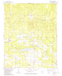
1980 Map of Ludwig
USGS Topo · Published 1980About this map
Lake Ludwig and the surrounding heights of the Ozark National Forest characterize this part of Johnson County, where the landscape transitions from industrial extraction to agricultural research. In the southern half of the quadrangle, several Strip Mine operations and numerous Gas Wells indicate the active energy production of the late 1970s. This industrial presence is contrasted by the University of Arkansas Experimental Farm, which occupies land near Lick Mountain. Local genealogy is well-documented through scattered family burial grounds and congregations, including Johnson Cem, King Cem, and Mt Zion Ch. The rugged terrain is punctuated by landmarks such as Spainhour Falls and Stillwell Mountain, while the small community of Ludwig serves as a central point for the local road network. The map preserves the era's balance between the preservation of the national forest and the economic utility of the land.
Find a feature on this map
65 named features on this map. Tap any name to fly to it.
Don’t see what you’re looking for? This feature index may not catch every label — zoom into the map to look around manually.
Map Details
Editions of this 1980 Ludwig Map
This is the sole edition of this map. No revisions or reprints were ever made.
Other maps of this area

1887 · Magazine Mountain #1
USGS Topo · 1:62,500

1887 · Magazine Mountain
USGS Topo · 1:62,500

1888 · Dardanelle #2
USGS Topo · 1:62,500

1889 · Ozone
USGS Topo · 1:62,500

1890 · Magazine Mountain
USGS Topo · 1:125,000

1890 · Dardanelle
USGS Topo · 1:125,000

1906 · Batson
USGS Topo · 1:62,500

1934 · Ozone
USGS Topo · 1:62,500

1936 · Ozone
USGS Topo · 1:62,500

1956 · Russellville
USGS Topo · 1:250,000