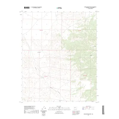
2023 Map of Luera Mountains West
USGS Topo · Published 2023About this map
Luera Peak stands as the dominant topographical feature in this high-altitude landscape of Catron County, part of the larger Luera Mountains range. The terrain is defined by a complex network of drainages and seasonal water management, including the Above Hay Pasture Tank. Deep relief is visible throughout the area, notably within Cañon Obscura and the winding Obaro Canyon, which cut through the uplifted territory. Access to this high-country environment is limited to routes like Forest Rd 30, reflecting a landscape primarily used for ranching and forest management rather than dense settlement. The map provides a clear look at the Public Land Survey System grid, specifically within townships t5s r11w and t6s r11w, illustrating how 21st-century land divisions are still organized around these established sections and range lines.
Find a feature on this map
11 named features on this map. Tap any name to fly to it.
Don’t see what you’re looking for? This feature index may not catch every label — zoom into the map to look around manually.
Map Details
Editions of this 2023 Luera Mountains West Map
This is the sole edition of this map. No revisions or reprints were ever made.
Other maps of this area

1918 · Pelona
USGS Topo · 1:125,000

1954 · Tularosa
USGS Topo · 1:250,000

1954 · Clifton
USGS Topo · 1:250,000

1957 · Clifton
USGS Topo · 1:250,000

1958 · Clifton
USGS Topo · 1:250,000

1958 · Tularosa
USGS Topo · 1:250,000

1962 · Clifton
USGS Topo · 1:250,000

1979 · San Mateo Mountains
USGS Topo · 1:100,000
1981 · Luera Mountains NW
USGS Topo · 1:24,000
1981 · Pelona Mountain
USGS Topo · 1:24,000