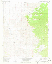
1981 Map of Luera Mountains West
USGS Topo · Published 1981About this map
Luera Peak and the high ridges of the Luera Mountains dominate this high-desert landscape in Catron County. The topography is defined by the sharp transition between the mountain heights and the descending drainage systems of Cañon Obscuro and Alamo Canyon. This 1981 edition, based on earlier 1970s field work, documents a remote ranching environment where life and industry revolve entirely around scarce water sources. Named landmarks like the Eloysia Windmill, Antelope Well, and Partnership Well indicate the scattered infrastructure necessary for survival and livestock management in the New Mexico interior. The distribution of these features, alongside the Above Hay Pasture Tank and Hay Pasture Windmill, provides a clear view of how land was partitioned and utilized for grazing at the end of the twentieth century.
Find a feature on this map
10 named features on this map. Tap any name to fly to it.
Don’t see what you’re looking for? This feature index may not catch every label — zoom into the map to look around manually.
Map Details
Editions of this 1981 Luera Mountains West Map
This is the sole edition of this map. No revisions or reprints were ever made.
Other maps of this area

1918 · Pelona
USGS Topo · 1:125,000

1954 · Tularosa
USGS Topo · 1:250,000

1954 · Clifton
USGS Topo · 1:250,000

1957 · Clifton
USGS Topo · 1:250,000

1958 · Clifton
USGS Topo · 1:250,000

1958 · Tularosa
USGS Topo · 1:250,000

1962 · Clifton
USGS Topo · 1:250,000

1979 · San Mateo Mountains
USGS Topo · 1:100,000
1981 · Luera Mountains NW
USGS Topo · 1:24,000
1981 · Pelona Mountain
USGS Topo · 1:24,000