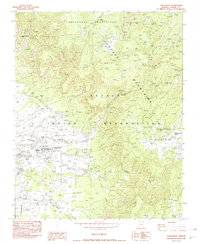
1982 Map of Lukachukai
USGS Topo · Published 1982About this map
The Navajo Indian Reservation landscape is defined by the dramatic meeting of the Chuska Mountains and the Tunitcha Mountains in this 1982 survey. At the base of these peaks, the community of Lukachukai serves as a local hub, featuring the St Isabel Mission, the Lukachukai Boarding Sch, and a Lukachukai Trading Post. The settlement patterns here follow the natural drainage of Lukachukai Creek and the Sand Wash, where the smaller settlement of Tohotso is also located.
Find a feature on this map
33 named features on this map. Tap any name to fly to it.
Don’t see what you’re looking for? This feature index may not catch every label — zoom into the map to look around manually.
Map Details
Editions of this 1982 Lukachukai Map
This is the sole edition of this map. No revisions or reprints were ever made.
Other maps of this area

1892 · Canyon De Chelly
USGS Topo · 1:250,000

1953 · Redrock Valley SE
USGS Topo · 1:24,000

1953 · Redrock Valley SW
USGS Topo · 1:24,000

1953 · Los Gigantes SE
USGS Topo · 1:24,000

1953 · Los Gigantes Buttes
USGS Topo · 1:62,500

1953 · Redrock Valley
USGS Topo · 1:62,500

1954 · Shiprock
USGS Topo · 1:250,000
1955 · Sonsala Butte 1 NW
USGS Topo · 1:24,000

1955 · Sonsala Butte 1 SE
USGS Topo · 1:24,000
1955 · Sonsala Butte 1 NE
USGS Topo · 1:24,000