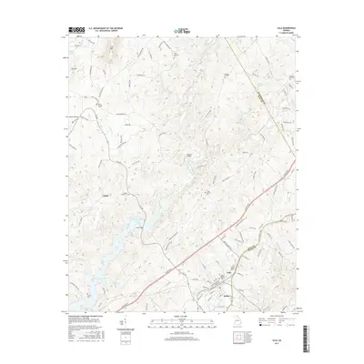
2017 Map of Lula
USGS Topo · Published 2017About this map
The Chattahoochee River and the northern reaches of Lake Sidney Lanier dominate this Northeast Georgia landscape, where the borders of Hall, Habersham, and Banks counties meet. This area reflects a long history of rural community life, anchored by the town of Lula and the nearby settlement of Bellton. A network of family and community landmarks is scattered across the terrain, including Holly Springs Ch, Clemons Chapel Cem, and Skitts Mountain Cem, which sits near the prominence of Skitt Mtn. To the west, Hog Mtn and Whitmore Lake provide distinct geographic markers. The modern infrastructure of the Lanier Pkwy intersects with older routes like Old Mill Rd and Crane Mill Rd, tracing the evolution of local commerce and transport from early milling operations to contemporary thoroughfares. These features collectively illustrate the transition from isolated Piedmont farmsteads to a more connected regional hub.
Find a feature on this map
116 named features on this map. Tap any name to fly to it.
Don’t see what you’re looking for? This feature index may not catch every label — zoom into the map to look around manually.
Map Details
Editions of this 2017 Lula Map
This is the sole edition of this map. No revisions or reprints were ever made.
Other maps of this area

1886 · Dahlonega
USGS Topo · 1:125,000

1891 · Gainesville
USGS Topo · 1:125,000

1892 · Dahlonega
USGS Topo · 1:125,000

1896 · Dahlonega
USGS Topo · 1:125,000

1903 · Dahlonega
USGS Topo · 1:125,000

1951 · Cleveland
USGS Topo · 1:24,000

1954 · Greenville
USGS Topo · 1:250,000

1958 · Greenville
USGS Topo · 1:250,000

1964 · Maysville
USGS Topo · 1:24,000

1964 · Lula
USGS Topo · 1:24,000