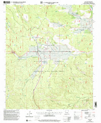
1999 Map of Luna
USGS Topo · Published 2002About this map
The settlement of Luna serves as the focal point of this high-country survey, situated within the Luna Valley where the San Francisco River begins its course. This area of Catron County reflects a landscape defined by ranching and forestry operations within the Apache National Forest, marked by the presence of a Sawmill, the Rodeo Grounds, and a Shipping Corral. Local history is preserved at the town's Cem and at homesteads like the Ruyle Place and Old Campbell Place.
Find a feature on this map
52 named features on this map. Tap any name to fly to it.
Don’t see what you’re looking for? This feature index may not catch every label — zoom into the map to look around manually.
Map Details
Editions of this 1999 Luna Map
This is the sole edition of this map. No revisions or reprints were ever made.
Other maps of this area

1915 · Reserve
USGS Topo · 1:125,000

1918 · Reserve
USGS Topo · 1:125,000

1922 · Nutrioso
USGS Topo · 1:125,000

1954 · Clifton
USGS Topo · 1:250,000

1957 · Clifton
USGS Topo · 1:250,000

1958 · Clifton
USGS Topo · 1:250,000

1958 · Alpine
USGS Topo · 1:62,500

1961 · Blue
USGS Topo · 1:62,500

1962 · Clifton
USGS Topo · 1:250,000
1965 · Reserve
USGS Topo · 1:24,000