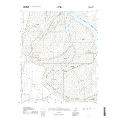
2020 Map of Luna
USGS Topo · Published 2020About this map
Old River and the complex meanders of the Mississippi define this landscape along the Arkansas and Mississippi state line. The map captures a high-water environment of backwaters and necks, including the oxbow formation of Lake Paradise and the extensive Ashbrook Neck. The settlement of Luna sits near the banks of the river, while the small community of Dewey and the Panther Forest Crevasse reflect the area's history of managing the volatile river delta. The terrain is marked by numerous islands and bars such as Island Number 81 and Luna Bar, indicating the shifting nature of the river channel over time. Prominent ridges and hills like Backbone Ridge and Hardwood Hill provide the few points of elevation in an otherwise wetland-dominated region. The presence of features like Ashbrook Cutoff and Eunice Chute illustrates the engineered and natural changes to the waterway that have dictated the local economy and geography for generations.
Find a feature on this map
57 named features on this map. Tap any name to fly to it.
Don’t see what you’re looking for? This feature index may not catch every label — zoom into the map to look around manually.
Map Details
Editions of this 2020 Luna Map
This is the sole edition of this map. No revisions or reprints were ever made.
Other maps of this area

1933 · Lamont
USGS Topo · 1:62,500

1936 · McGehee
USGS Topo · 1:62,500

1936 · Lake Village
USGS Topo · 1:62,500

1937 · McGehee
USGS Topo · 1:62,500

1939 · Refuge
USGS Topo · 1:62,500

1939 · Lamont
USGS Topo · 1:62,500

1953 · Greenwood
USGS Topo · 1:250,000

1955 · Lake Village
USGS Topo · 1:62,500

1955 · McGehee
USGS Topo · 1:62,500

1956 · Greenwood
USGS Topo · 1:250,000