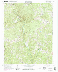
1966 Map of Lunenburg
USGS Topo · Published 1975About this map
Loves Mill and the surrounding Southside landscape are defined by the winding course of the North Meherrin River and its numerous tributaries. This mid-1960s environment, updated with 1974 revisions, reveals a pattern of rural crossroads and community hubs such as Lunenburg and Wattsboro. The area is notably dense with localized places of worship, including Tussekiak Ch, New Rehoboth Ch, and Bethany Ch, which serve as primary landmarks for genealogists tracing family ties in Lunenburg County. The map captures a transition toward modern infrastructure with purple photorevisions showing expanded road networks and a pipeline crossing through Pleasant Grove. From the Lookout Tower near the county seat to the small commercial outpost at Crymes Store, the document preserves the spatial layout of Virginia's Piedmont before late-20th-century development altered these historic rural centers.
Find a feature on this map
23 named features on this map. Tap any name to fly to it.
Don’t see what you’re looking for? This feature index may not catch every label — zoom into the map to look around manually.
Map Details
Editions of this 1966 Lunenburg Map
Other maps of this area

1891 · Farmville
USGS Topo · 1:125,000

1893 · Farmville
USGS Topo · 1:125,000

1947 · Roanoke
USGS Topo · 1:250,000

1953 · Greensboro
USGS Topo · 1:250,000

1954 · Greensboro
USGS Topo · 1:250,000

1955 · Chase City
USGS Topo · 1:62,500

1955 · Kenbridge
USGS Topo · 1:62,500

1958 · Crewe
USGS Topo · 1:62,500

1958 · Keysville
USGS Topo · 1:62,500

1959 · Roanoke
USGS Topo · 1:250,000