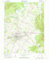
1965 Map of Luray
USGS Topo · Published 1973About this map
The South Fork Shenandoah River winds through the heart of the Page Valley, flanked by the high ridges of Massanutten Mountain to the west and the Blue Ridge to the east. This 1960s landscape shows the town of Luray as a regional hub centered on the Norfolk and Western railroad and the famed Luray Caverns. While the river valley supports farming settlements like Springfield and Oak Hill, the eastern slopes are preserved within Shenandoah National Park, featuring the Jeremys Run Trail. Local community life is anchored by a dense network of country churches, including Bethlehem Ch and Antioch Ch, alongside recreational landmarks like the Drive-in Theater and the Fairgrounds. The topography reveals the complex hydrology of the region, from the cavern-riddled Cave Hill to the controlled waters of the Luray Reservoir.
Find a feature on this map
61 named features on this map. Tap any name to fly to it.
Don’t see what you’re looking for? This feature index may not catch every label — zoom into the map to look around manually.
Map Details
Editions of this 1965 Luray Map
3 editions found
Other maps of this area

1892 · Woodstock
USGS Topo · 1:125,000

1893 · Luray
USGS Topo · 1:125,000

1905 · Luray
USGS Topo · 1:125,000

1923 · Edinburg
USGS Topo · 1:62,500

1929 · Stony Man
USGS Topo · 1:48,000

1933 · Stony Man
USGS Topo · 1:62,500

1942 · Mt Jackson
USGS Topo · 1:62,500

1946 · Mt Jackson
USGS Topo · 1:62,500

1947 · Mt Jackson
USGS Topo · 1:62,500

1947 · Strasburg
USGS Topo · 1:62,500