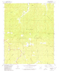
1980 Map of Lurton
USGS Topo · Published 1980About this map
Lurton and Spence Junction serve as the primary human outposts in this 1980 survey of the Ozark highlands in Newton County. The landscape is defined by the heavy dissection of high ridges and plateaus, with notable summits like Hudson Mountain, Ketcherside Mtn, and the distinctive Sams Throne rising above the deep drainage basins. The settlement pattern follows the high ground of Tarlton Flats, where the Tarlton Cem preserves local family history near the headwaters of the Tilly Creek and Big Creek systems. Within the Ozark National Forest, the map details a complex network of hollows such as Boss Hollow, Cox Hollow, and Rock House Hollow, illustrating the difficult terrain that shaped early transportation and land use in this part of the Boston Mountains. State Routes 16 and 123 provide the main corridors through these remote reaches, connecting isolated knobs like Sassafras Knob to the broader regional network.
Find a feature on this map
73 named features on this map. Tap any name to fly to it.
Don’t see what you’re looking for? This feature index may not catch every label — zoom into the map to look around manually.
Map Details
Editions of this 1980 Lurton Map
3 editions found
Other maps of this area

1879 · Washington
USGS Topo · 1:62,500

1887 · Smyrna
USGS Topo · 1:62,500

1889 · Treat
USGS Topo · 1:62,500

1889 · Marshall #3
USGS Topo · 1:62,500

1892 · Marshall
USGS Topo · 1:125,000

1894 · Marshall
USGS Topo · 1:125,000

1901 · Marshall
USGS Topo · 1:125,000

1932 · Treat
USGS Topo · 1:62,500

1933 · Mt Judea
USGS Topo · 1:62,500

1934 · Treat
USGS Topo · 1:62,500