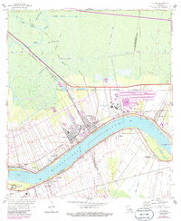
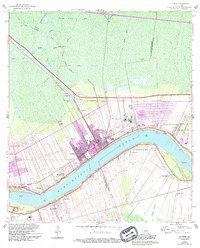
1962 Map of Lutcher
USGS Topo · Published 1986About this map
The Mississippi River defines the landscape of this river-parish corridor, winding past established settlements like Gramercy, Lutcher, and Paulina. This mid-century survey reveals the deep-rooted agricultural and industrial patterns of the region, from the historic Evergreen Plantation to the extensive Tailings Ponds near the riverbank. The map is particularly valuable for genealogists, as it documents several local burial grounds including St Joseph Cem, Antioch Cem, and Woodville Cem.
Find a feature on this map
45 named features on this map. Tap any name to fly to it.
Don’t see what you’re looking for? This feature index may not catch every label — zoom into the map to look around manually.
Map Details
Editions of this 1962 Lutcher Map
5 editions found
Other maps of this area

1892 · Lac Des Allemands
USGS Topo · 1:62,500

1892 · Mount Airy
USGS Topo · 1:62,500

1892 · Donaldsonville
USGS Topo · 1:62,500

1892 · Thibodaux
USGS Topo · 1:62,500

1932 · Lac Des Allemands NW
USGS Topo · 1:31,680

1932 · Thibodaux NE
USGS Topo · 1:31,680

1932 · Lac Des Allemands NE
USGS Topo · 1:31,680

1939 · Donaldsonville
USGS Topo · 1:62,500

1940 · Lagan
USGS Topo · 1:31,680
1941 · Lac Des Allemands
USGS Topo · 1:62,500