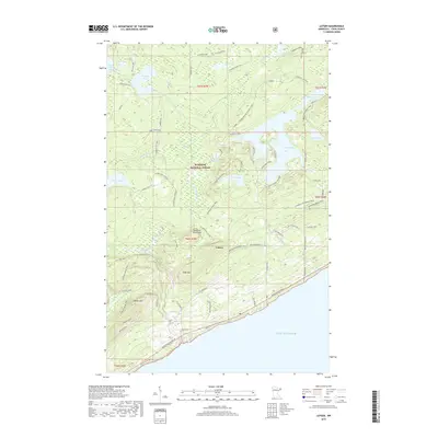
2019 Map of Lutsen
USGS Topo · Published 2019About this map
Lake Superior defines the southern edge of this North Shore landscape, where the terrain rises sharply from the shoreline into the Sawtooth Mountains. The settlement of Lutsen sits at this junction, serving as a gateway to the recreational and timber lands of the Superior National Forest. Significant elevation changes are marked by prominent peaks like Eagle Mtn and Moose Mtn, which overlook a dense network of water bodies including Caribou Lake, Lake Agnes, and Christine Lake.
Find a feature on this map
65 named features on this map. Tap any name to fly to it.
Don’t see what you’re looking for? This feature index may not catch every label — zoom into the map to look around manually.
Map Details
Editions of this 2019 Lutsen Map
This is the sole edition of this map. No revisions or reprints were ever made.
Other maps of this area

1919 · Brule Lake
USGS Topo · 1:62,500

1919 · Lutsen
USGS Topo · 1:62,500

1954 · Two Harbors
USGS Topo · 1:250,000

1955 · Tofte
USGS Topo · 1:24,000

1955 · Tofte
USGS Topo · 1:62,500

1957 · Two Harbors
USGS Topo · 1:250,000

1958 · Two Harbors
USGS Topo · 1:250,000

1958 · Deer Yard Lake
USGS Topo · 1:24,000

1959 · Lutsen
USGS Topo · 1:24,000

1960 · Tait Lake
USGS Topo · 1:24,000