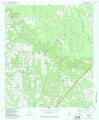
1971 Map of Lyeffion
USGS Topo · Published 1986About this map
The Sepulga River defines the landscape of this portion of Conecuh County, Alabama, where its western and eastern forks converge amidst a network of small agricultural settlements and timber stands. This 1971 survey highlights the rural community of Lyeffion and the nearby junction at Cooks Crossroads, serving as a record of a region defined by its local congregations and land management. Scattered throughout the terrain are numerous spiritual landmarks such as New Hope Ch, Little Pine Level Ch, and Antioch Ch, which often served as the social anchors for family farms in the mid-20th century.
Find a feature on this map
21 named features on this map. Tap any name to fly to it.
Don’t see what you’re looking for? This feature index may not catch every label — zoom into the map to look around manually.
Map Details
Editions of this 1971 Lyeffion Map
2 editions found
Other maps of this area

1953 · Andalusia
USGS Topo · 1:250,000

1957 · Andalusia
USGS Topo · 1:250,000

1971 · Lyeffion
USGS Topo · 1:24,000

1971 · Belleville
USGS Topo · 1:24,000

1971 · Garland
USGS Topo · 1:24,000

1971 · Skinnerton
USGS Topo · 1:24,000

1971 · China
USGS Topo · 1:24,000

1971 · Bethel
USGS Topo · 1:24,000

1971 · Georgiana West
USGS Topo · 1:24,000

1982 · Evergreen
USGS Topo · 1:24,000