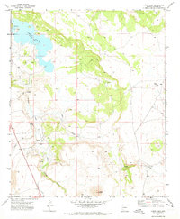
1971 Map of Lyman Lake
USGS Topo · Published 1973About this map
Lyman Lake serves as the centerpiece of this desert landscape in the early 1970s, established within the Lyman Lake State Park. Fed by the Little Colorado River, the reservoir supports local recreation, evidenced by a Boat Ramp and Campground on its western shore. The surrounding terrain is defined by its volcanic and riparian history, including the notable Lava field in the southwest and several seasonal watercourses like Coyote Creek and Carnero Creek. The presence of Richville and named water sources such as Neilson Spring highlights the area's agricultural reliance on the river's drainage. Numerous Jeep Trails and isolated Corrals cross the mesas, suggesting a landscape primarily dedicated to ranching and outdoor access during this era.
Find a feature on this map
17 named features on this map. Tap any name to fly to it.
Don’t see what you’re looking for? This feature index may not catch every label — zoom into the map to look around manually.
Map Details
Editions of this 1971 Lyman Lake Map
2 editions found
Other maps of this area

1886 · St Johns
USGS Topo · 1:250,000

1892 · St Johns
USGS Topo · 1:250,000

1954 · Saint Johns
USGS Topo · 1:250,000

1957 · Saint Johns
USGS Topo · 1:250,000

1958 · Saint Johns
USGS Topo · 1:250,000

1962 · Saint Johns
USGS Topo · 1:250,000

1968 · Springerville NW
USGS Topo · 1:24,000

1969 · Coyote Hills
USGS Topo · 1:24,000
1969 · Springerville
USGS Topo · 1:24,000

1971 · Mesa Parada NW
USGS Topo · 1:24,000