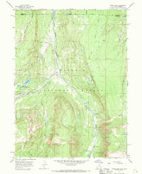
1967 Map of Lyman Lake
USGS Topo · Published 1969About this map
Old Blacks Fork Commissary and nearby ruins stand as markers of early human activity along the river drainage in this high-altitude landscape. During the late 1960s, this area of the Wasatch National Forest saw a significant transition as the Meeks Cabin Reservoir was being established, with blue hatching on the map indicating land designated to be submerged. The river system, including Blacks Fork, the West Fork, and Middle Fork Blacks Fork, dictates the movement through the terrain via numerous pack trails and a Jeep Trail.
Find a feature on this map
33 named features on this map. Tap any name to fly to it.
Don’t see what you’re looking for? This feature index may not catch every label — zoom into the map to look around manually.
Map Details
Editions of this 1967 Lyman Lake Map
2 editions found
Other maps of this area

1885 · Uinta
USGS Topo · 1:250,000

1901 · Hayden Peak
USGS Topo · 1:125,000

1903 · Hayden Peak
USGS Topo · 1:125,000

1905 · Gilbert Peak
USGS Topo · 1:125,000

1906 · Gilbert Peak
USGS Topo · 1:125,000

1954 · Salt Lake City
USGS Topo · 1:250,000

1954 · Ogden
USGS Topo · 1:250,000

1958 · Ogden
USGS Topo · 1:250,000

1958 · Salt Lake City
USGS Topo · 1:250,000

1960 · Ogden
USGS Topo · 1:250,000