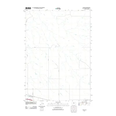
2012 Map of Lyman
USGS Topo · Published 2012About this map
Lyman sits at the southern edge of this central South Dakota prairie landscape, situated near the intersection of Lyman Rd and Petersons Rd. The surrounding terrain is defined by the winding course of Medicine Crk, which cuts through the northern sections of the map. This area of Lyman County reflects a traditional rural grid system, with thoroughfares like 238th St and 321st Ave providing structure to the open ranch and farmland. Small wetlands and depressions are scattered throughout the quadrangle, illustrating the natural drainage patterns that feed into Medicine Cr. The map's layout highlights the sparse settlement patterns typical of the region, where life is organized around a few key arterial roads and the water sources that have sustained agriculture in the area for generations.
Find a feature on this map
11 named features on this map. Tap any name to fly to it.
Don’t see what you’re looking for? This feature index may not catch every label — zoom into the map to look around manually.
Map Details
Editions of this 2012 Lyman Map
This is the sole edition of this map. No revisions or reprints were ever made.
Other maps of this area

1952 · Reliance SW
USGS Topo · 1:24,000

1952 · Reliance SE
USGS Topo · 1:24,000

1953 · Huron
USGS Topo · 1:250,000

1954 · Huron
USGS Topo · 1:250,000

1955 · Mitchell
USGS Topo · 1:250,000

1959 · Mitchell
USGS Topo · 1:250,000

1966 · Lower Brule SW
USGS Topo · 1:24,000

1966 · Joe Creek SE
USGS Topo · 1:24,000

1966 · Lower Brule
USGS Topo · 1:24,000
1978 · Lyman
USGS Topo · 1:24,000