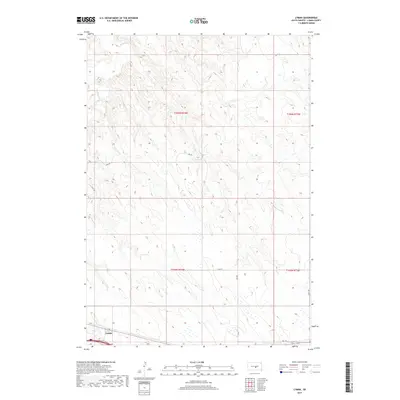
2017 Map of Lyman
USGS Topo · Published 2017About this map
Lyman sits in the southern portion of this landscape, positioned along the historical corridor of Hwy 16. The terrain is defined by the winding course of Medicine Cr in the northwest and a network of section-line roads that organize the rural geography. This 2017 survey by the U.S. Geological Survey illustrates a high-plains landscape where traditional township and range divisions, such as t106n r74w and t105n r73w, dictate the placement of transportation routes. Local transit is facilitated by numbered arteries including 321st Ave and 241st St, which connect the scattered agricultural tracts to the central hub at Lyman. The map preserves the specific orientation of these roads and watercourses before further modern development or landscape changes, providing a precise record of the county's infrastructure in the early 21st century.
Find a feature on this map
12 named features on this map. Tap any name to fly to it.
Don’t see what you’re looking for? This feature index may not catch every label — zoom into the map to look around manually.
Map Details
Editions of this 2017 Lyman Map
This is the sole edition of this map. No revisions or reprints were ever made.
Other maps of this area

1952 · Reliance SW
USGS Topo · 1:24,000

1952 · Reliance SE
USGS Topo · 1:24,000

1953 · Huron
USGS Topo · 1:250,000

1954 · Huron
USGS Topo · 1:250,000

1955 · Mitchell
USGS Topo · 1:250,000

1959 · Mitchell
USGS Topo · 1:250,000

1966 · Lower Brule SW
USGS Topo · 1:24,000

1966 · Joe Creek SE
USGS Topo · 1:24,000

1966 · Lower Brule
USGS Topo · 1:24,000
1978 · Lyman
USGS Topo · 1:24,000