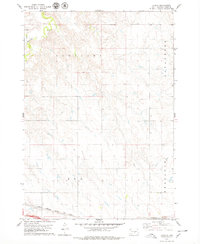
1978 Map of Lyman
USGS Topo · Published 1979About this map
The town of Lyman sits at the southwestern edge of this 1970s South Dakota landscape, serving as a focal point for the surrounding rural townships. The Chicago Milwaukee St Paul and Pacific railroad cuts through the southern reaches of the map, illustrating the critical role of rail transport in the regional economy during the late twentieth century. In the northwest corner, Medicine Creek carves a distinctive path through the terrain, with nearby quarries indicating local industrial activity. The area is clearly divided by several administrative boundaries, including the townships of Pleasant, Lafayette, Reliance, and Rex. This survey provides a clear look at the intersection of prairie topography and the structured township system typical of the Great Plains.
Find a feature on this map
9 named features on this map. Tap any name to fly to it.
Don’t see what you’re looking for? This feature index may not catch every label — zoom into the map to look around manually.
Map Details
Editions of this 1978 Lyman Map
This is the sole edition of this map. No revisions or reprints were ever made.
Other maps of this area

1952 · Reliance SW
USGS Topo · 1:24,000

1952 · Reliance SE
USGS Topo · 1:24,000

1953 · Huron
USGS Topo · 1:250,000

1954 · Huron
USGS Topo · 1:250,000

1955 · Mitchell
USGS Topo · 1:250,000

1959 · Mitchell
USGS Topo · 1:250,000

1966 · Lower Brule SW
USGS Topo · 1:24,000

1966 · Joe Creek SE
USGS Topo · 1:24,000

1966 · Lower Brule
USGS Topo · 1:24,000
1978 · Kennebec SE
USGS Topo · 1:24,000