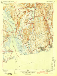
1941 Map of Lyme
USGS Topo · Published 1941About this map
Old Lyme and Old Saybrook flank the mouth of the Connecticut River in this survey conducted just before the United States entered the second World War. The map shows a landscape defined by the intersection of rail and river, with the New York New Haven and Hartford railroad crossing the water near Lyme Sta. To the east, large tracts are designated as a Military Reservation, while the shoreline remains a mix of established villages and seasonal retreats like Point o' Woods and Sound View. Interior hills such as Bills Hill and Amon Hill overlook a network of tidal marshes and ponds, including Lords Cove and Black Hall Pond. Small local landmarks like the Bills Hill Sch and family burial grounds including Ely Cem and Champion Cem offer specific touchpoints for local historians and genealogists.
Find a feature on this map
79 named features on this map. Tap any name to fly to it.
Don’t see what you’re looking for? This feature index may not catch every label — zoom into the map to look around manually.
Map Details
Editions of this 1941 Lyme Map
2 editions found

Other maps of this area

1892 · New London
USGS Topo · 1:62,500

1893 · New London
USGS Topo · 1:62,500

1893 · Saybrook
USGS Topo · 1:62,500

1903 · Gardiners Island
USGS Topo · 1:62,500

1904 · Gardiners Island
USGS Topo · 1:62,500

1921 · Gardiners Island
USGS Topo · 1:62,500

1921 · New London
USGS Topo · 1:62,500

1934 · Niantic
USGS Topo · 1:24,000

1935 · Montville
USGS Topo · 1:24,000

1938 · Niantic
USGS Topo · 1:62,500