
1941 Map of Lyme
USGS Topo · Published 1941About this map
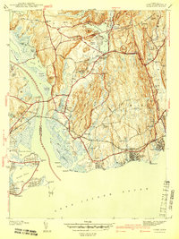
Lyme Sta and the New York New Haven and Hartford railroad define the coastal infrastructure of this New London County landscape as it appeared just before World War II. The settlement at Old Lyme serves as a hub, surrounded by a complex network of waterways including the Lieutenant River and Black Hall River. Further inland, the character of the land shifts toward small clusters like Laysville and the Bills Hill Sch, suggesting a community still deeply tied to its local hills and ponds.
Find a feature on this map
84 named features on this map. Tap any name to fly to it.
Don’t see what you’re looking for? This feature index may not catch every label — zoom into the map to look around manually.
Map Details
Editions of this 1941 Lyme Map
2 editions found
Other maps of this area

1892 · New London
USGS Topo · 1:62,500

1893 · New London
USGS Topo · 1:62,500

1893 · Saybrook
USGS Topo · 1:62,500

1903 · Gardiners Island
USGS Topo · 1:62,500

1904 · Gardiners Island
USGS Topo · 1:62,500

1921 · Gardiners Island
USGS Topo · 1:62,500

1921 · New London
USGS Topo · 1:62,500

1934 · Niantic
USGS Topo · 1:24,000

1935 · Montville
USGS Topo · 1:24,000

1938 · Niantic
USGS Topo · 1:62,500