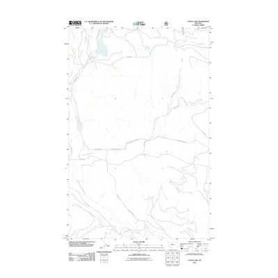
2011 Map of Lynch Lake
USGS Topo · Published 2011About this map
Island Lake and Lynch Lake anchor this 2011 survey of Flathead County, illustrating a landscape defined by its timber and drainage history. The presence of Old Railroad Grade Rd near Coniff Creek indicates the area's industrial legacy, where rail lines once serviced the remote forest interior. The southern portion of the quadrangle is dominated by the flow of the Pleasant Valley Fisher River, which collects waters from Pleasant Valley Creek and Island Creek. This network of waterways and Forest Service roads, such as Pleasant Valley Rd and Island Lake Rd, provides a clear view of the modern infrastructure overlaid on a terrain shaped by historical logging operations and natural watersheds in northwestern Montana.
Find a feature on this map
14 named features on this map. Tap any name to fly to it.
Don’t see what you’re looking for? This feature index may not catch every label — zoom into the map to look around manually.
Map Details
Editions of this 2011 Lynch Lake Map
This is the sole edition of this map. No revisions or reprints were ever made.
Other maps of this area

1920 · Jennings
USGS Topo · 1:125,000

1935 · Thompson Lakes
USGS Topo · 1:96,000

1942 · Thompson Lakes
USGS Topo · 1:125,000

1957 · Kalispell
USGS Topo · 1:250,000

1960 · Kalispell
USGS Topo · 1:250,000

1961 · Kalispell
USGS Topo · 1:250,000

1963 · Wolf Prairie
USGS Topo · 1:24,000

1963 · Sylvia Lake
USGS Topo · 1:24,000
1963 · Horse Hill
USGS Topo · 1:24,000

1964 · Meadow Peak
USGS Topo · 1:24,000