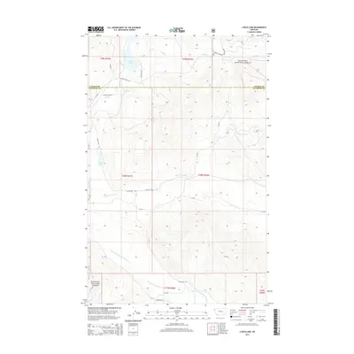
2014 Map of Lynch Lake
USGS Topo · Published 2014About this map
Kootenai National Forest dominates the high country of northwest Montana in this 2014 survey, where the boundaries of Lincoln and Flathead Counties intersect. The landscape is defined by a dense network of watercourses and forest service access routes, including Forest Develop Road 2349 and Lost Prairie Rd. Glacial relics like Island Lake and Lynch Lake are fed by mountain streams such as Island Cr and Coniff Cr. The southern portion of the quadrangle shows the drainage of the Pleasant Valley Fisher River, a critical hydrological feature of the region. This modern topographic record captures the area's transition from traditional forest management toward recreational use, evidenced by named loops like Discovery Loop and established rural arteries like Pleasant Valley Rd.
Find a feature on this map
25 named features on this map. Tap any name to fly to it.
Don’t see what you’re looking for? This feature index may not catch every label — zoom into the map to look around manually.
Map Details
Editions of this 2014 Lynch Lake Map
This is the sole edition of this map. No revisions or reprints were ever made.
Other maps of this area

1920 · Jennings
USGS Topo · 1:125,000

1935 · Thompson Lakes
USGS Topo · 1:96,000

1942 · Thompson Lakes
USGS Topo · 1:125,000

1957 · Kalispell
USGS Topo · 1:250,000

1960 · Kalispell
USGS Topo · 1:250,000

1961 · Kalispell
USGS Topo · 1:250,000

1963 · Wolf Prairie
USGS Topo · 1:24,000

1963 · Sylvia Lake
USGS Topo · 1:24,000
1963 · Horse Hill
USGS Topo · 1:24,000

1964 · Meadow Peak
USGS Topo · 1:24,000