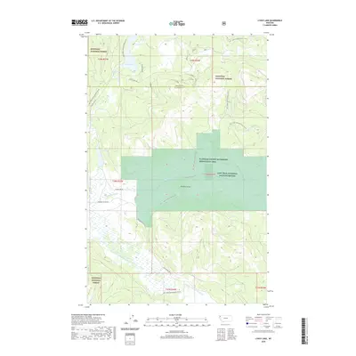
2020 Map of Lynch Lake
USGS Topo · Published 2020About this map
Pleasant Valley and its surrounding wetlands form the heart of this landscape, where conservation efforts are deeply etched into the topography. The Lost Trail National Wildlife Refuge and the Flathead County Waterfowl Production Area dominate the central basin, preserving a complex system of marshes and riparian zones along Pleasant Valley Cr. To the west and south, the terrain transitions into the managed timberlands of the Kootenai National Forest.
Find a feature on this map
30 named features on this map. Tap any name to fly to it.
Don’t see what you’re looking for? This feature index may not catch every label — zoom into the map to look around manually.
Map Details
Editions of this 2020 Lynch Lake Map
This is the sole edition of this map. No revisions or reprints were ever made.
Other maps of this area

1920 · Jennings
USGS Topo · 1:125,000

1935 · Thompson Lakes
USGS Topo · 1:96,000

1942 · Thompson Lakes
USGS Topo · 1:125,000

1957 · Kalispell
USGS Topo · 1:250,000

1960 · Kalispell
USGS Topo · 1:250,000

1961 · Kalispell
USGS Topo · 1:250,000

1963 · Wolf Prairie
USGS Topo · 1:24,000

1963 · Sylvia Lake
USGS Topo · 1:24,000
1963 · Horse Hill
USGS Topo · 1:24,000

1964 · Meadow Peak
USGS Topo · 1:24,000