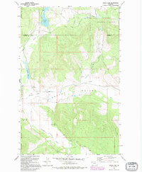
1991 Map of Lynch Lake
USGS Topo · Published 1995About this map
Pleasant Valley and the surrounding timberlands of the Kootenai National Forest define this landscape along the border of Lincoln and Flathead Counties. The drainage systems are the primary focal points of the terrain, with Coniff Creek and Pleasant Valley Creek feeding into the south-flowing Fisher River. This 1991 revision, based on earlier 1963 imagery, shows a region characterized by isolated water bodies like Island Lake and the unusually named Island Lynch Lake. Rural infrastructure is sparse, concentrated primarily on the Pleasant Valley Sch and a scattered network of forest roads and light-duty routes. A small Gravel Pit near the river indicates local resource extraction, while the presence of a Well and specific Springs suggests the importance of groundwater in this montane environment.
Find a feature on this map
14 named features on this map. Tap any name to fly to it.
Don’t see what you’re looking for? This feature index may not catch every label — zoom into the map to look around manually.
Map Details
Editions of this 1991 Lynch Lake Map
This is the sole edition of this map. No revisions or reprints were ever made.
Other maps of this area

1920 · Jennings
USGS Topo · 1:125,000

1935 · Thompson Lakes
USGS Topo · 1:96,000

1942 · Thompson Lakes
USGS Topo · 1:125,000

1957 · Kalispell
USGS Topo · 1:250,000

1960 · Kalispell
USGS Topo · 1:250,000

1961 · Kalispell
USGS Topo · 1:250,000

1963 · Wolf Prairie
USGS Topo · 1:24,000

1963 · Sylvia Lake
USGS Topo · 1:24,000
1963 · Horse Hill
USGS Topo · 1:24,000

1964 · Meadow Peak
USGS Topo · 1:24,000