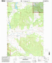
1997 Map of Lynch Lake
USGS Topo · Published 2000About this map
Pleasant Valley defines the central topography of this landscape, where the wide basin of Pleasant Valley Creek cuts through the timbered reaches of the Kootenai National Forest. The presence of the Pleasant Valley School near the creek indicates a persistent, if sparse, community hub amidst the surrounding forest lands. Mapping here captures a transition from high ridges down to the valley floor, where water features like Island Lake and Lynch Lake provide significant landmarks against the mountainous backdrop.
Find a feature on this map
15 named features on this map. Tap any name to fly to it.
Don’t see what you’re looking for? This feature index may not catch every label — zoom into the map to look around manually.
Map Details
Editions of this 1997 Lynch Lake Map
This is the sole edition of this map. No revisions or reprints were ever made.
Other maps of this area

1920 · Jennings
USGS Topo · 1:125,000

1935 · Thompson Lakes
USGS Topo · 1:96,000

1942 · Thompson Lakes
USGS Topo · 1:125,000

1957 · Kalispell
USGS Topo · 1:250,000

1960 · Kalispell
USGS Topo · 1:250,000

1961 · Kalispell
USGS Topo · 1:250,000

1963 · Wolf Prairie
USGS Topo · 1:24,000

1963 · Sylvia Lake
USGS Topo · 1:24,000
1963 · Horse Hill
USGS Topo · 1:24,000

1964 · Meadow Peak
USGS Topo · 1:24,000