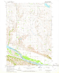
1964 Map of Lynch NE
USGS Topo · Published 1966About this map
The Missouri River corridor defines the southern edge of this mid-1960s survey, where the Yankton Indian Reservation Boundary meets the South Dakota-Nebraska state line. The landscape is marked by historical demarcations, including the Old Indian Treaty Boundary, which cuts across the terrain of Highland, Lawrence, and Wahehe.
Find a feature on this map
27 named features on this map. Tap any name to fly to it.
Don’t see what you’re looking for? This feature index may not catch every label — zoom into the map to look around manually.
Map Details
Editions of this 1964 Lynch NE Map
2 editions found
Other maps of this area

1950 · Verdel
USGS Topo · 1:24,000

1950 · Lynch
USGS Topo · 1:24,000

1950 · Monowi
USGS Topo · 1:24,000

1952 · Monowi
USGS Topo · 1:24,000

1955 · Mitchell
USGS Topo · 1:250,000

1955 · O'Neill
USGS Topo · 1:250,000

1959 · O'Neill
USGS Topo · 1:250,000

1959 · Mitchell
USGS Topo · 1:250,000

1964 · Wagner
USGS Topo · 1:24,000

1964 · Lynch NE
USGS Topo · 1:24,000
Featured Places
- Lawrence Township, SD
- Plain Center Township, SD
- Ree Township, SD
- Wahehe Township, SD
- Charles Mix County, SD