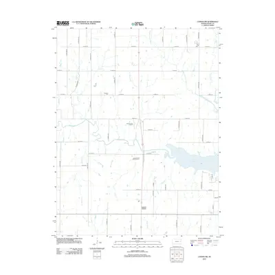
2012 Map of Lyndon NW
USGS Topo · Published 2012About this map
Lyndon Station serves as the primary focal point of this Osage County landscape, situated just south of the sprawling waters of Pomona Lake. The terrain is defined by an intricate network of waterways, including Dragoon Cr, Hundred and Ten Mile Cr, and Opossum Cr, which carve through the agricultural grid. This 2012 survey illustrates the intersection of rural heritage and recreation, with Highland Cem preserved near Wolf Cr while modern activity is represented by the Pomona Lake Airport and the Dragoon Creek Motocross Park. The map's detailed road system, including S California Rd and S Morrill Rd, reveals how the township is organized around these essential water sources and the large reservoir to the east. For local historians, the placement of these creek-fed basins and family-named roads offers a clear view of how development has adapted to the natural drainage patterns of the region.
Find a feature on this map
40 named features on this map. Tap any name to fly to it.
Don’t see what you’re looking for? This feature index may not catch every label — zoom into the map to look around manually.
Map Details
Editions of this 2012 Lyndon NW Map
This is the sole edition of this map. No revisions or reprints were ever made.
Other maps of this area

1889 · Burlingame
USGS Topo · 1:125,000

1894 · Burlingame
USGS Topo · 1:125,000

1947 · Lawrence
USGS Topo · 1:250,000

1950 · Lawrence
USGS Topo · 1:250,000

1952 · Burlingame
USGS Topo · 1:24,000

1955 · Overbrook
USGS Topo · 1:24,000

1955 · Carbondale
USGS Topo · 1:24,000

1956 · Lawrence
USGS Topo · 1:250,000

1961 · Lawrence
USGS Topo · 1:250,000
1965 · Lyndon
USGS Topo · 1:24,000