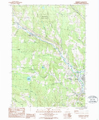
1986 Map of Lyndonville
USGS Topo · Published 1987About this map
Lyndonville serves as the primary hub in this mid-1980s Northeast Kingdom landscape, where the Passumpsic River and Miller Run converge. The area’s academic and civic character is anchored by Lyndon State College and the Caledonia County Airport, situated near the winding course of Quimby Brook. To the north and west, the terrain rises into the Mathewson State Forest, a landscape defined by the steep slopes of Hammond Hill and Mathewson Hill.
Find a feature on this map
40 named features on this map. Tap any name to fly to it.
Don’t see what you’re looking for? This feature index may not catch every label — zoom into the map to look around manually.
Map Details
Editions of this 1986 Lyndonville Map
2 editions found
Other maps of this area

1931 · Littleton
USGS Topo · 1:62,500

1932 · Littleton
USGS Topo · 1:48,000

1935 · Littleton
USGS Topo · 1:62,500

1935 · Lyndonville
USGS Topo · 1:48,000

1938 · St. Johnsbury
USGS Topo · 1:48,000

1939 · Lyndonville
USGS Topo · 1:62,500

1943 · St. Johnsbury
USGS Topo · 1:62,500
1949 · St. Johnsbury
USGS Topo · 1:62,500

1950 · Lake Champlain
USGS Topo · 1:250,000

1950 · Lewiston
USGS Topo · 1:250,000