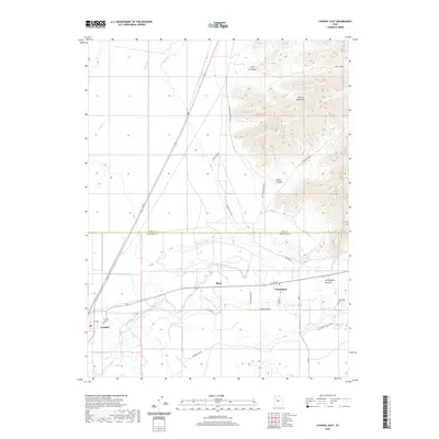
2020 Map of Lynndyl East
USGS Topo · Published 2020About this map
The Sevier River carves through the heart of this landscape near the border of Juab and Millard counties, providing a vital water source for a complex network of irrigation systems. Settlements like Leamington and Lynndyl are situated along this river corridor, where the Leamington Canal, Mcintyre Canal, and the Central Utah Canal branch out to support the local agriculture. To the northeast, the terrain rises sharply into the Gilson Mountains, characterized by deep cuts such as Broad Canyon and Long Canyon. This geography highlights the late-twentieth-century reliance on managed water within the arid Great Basin, where the small community of Mack and local landmarks like the Leamington Cem and Lynndyl Cem serve as focal points for local history and genealogy. The infrastructure, including the Main rail line and various rural roads like Lemington Rd, underscores the importance of transportation and water management in this high-desert environment.
Find a feature on this map
30 named features on this map. Tap any name to fly to it.
Don’t see what you’re looking for? This feature index may not catch every label — zoom into the map to look around manually.
Map Details
Editions of this 2020 Lynndyl East Map
This is the sole edition of this map. No revisions or reprints were ever made.
Other maps of this area

1885 · Sevier Desert
USGS Topo · 1:250,000

1951 · Oak City
USGS Topo · 1:62,500

1952 · Scipio North
USGS Topo · 1:62,500

1953 · Delta
USGS Topo · 1:250,000

1958 · Delta
USGS Topo · 1:250,000

1962 · Delta
USGS Topo · 1:250,000

1962 · Lynndyl
USGS Topo · 1:62,500

1967 · Champlin Peak
USGS Topo · 1:24,000
1967 · Jericho
USGS Topo · 1:24,000

1979 · Lynndyl
USGS Topo · 1:100,000