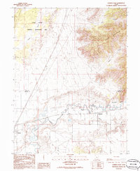
1986 Map of Lynndyl East
USGS Topo · Published 1986About this map
The Sevier River meanders across this landscape at the border of Juab and Millard counties, supporting a complex network of irrigation infrastructure including the Central Utah Canal, Mc Intyre Canal, and Leamington Canal. This mid-1980s provisional survey shows the rail-and-water economy of the region, where the Union Pacific tracks connect the settlements of Lynndyl, Mack, and Leamington. To the north, the terrain transitions sharply from the alluvial flats near the river to the desert landscape of the Little Sahara National Recreation Area, while the Gilson Mountains rise in the northeast corner of the sheet. The map documents the specific drainage patterns of Tanner Creek and several deep cuts through the highlands, such as Long Canyon and Leamington Canyon, illustrating the varied topography between the sand dunes and the mountain peaks.
Find a feature on this map
16 named features on this map. Tap any name to fly to it.
Don’t see what you’re looking for? This feature index may not catch every label — zoom into the map to look around manually.
Map Details
Editions of this 1986 Lynndyl East Map
This is the sole edition of this map. No revisions or reprints were ever made.
Other maps of this area

1885 · Sevier Desert
USGS Topo · 1:250,000

1951 · Oak City
USGS Topo · 1:62,500

1952 · Scipio North
USGS Topo · 1:62,500

1953 · Delta
USGS Topo · 1:250,000

1958 · Delta
USGS Topo · 1:250,000

1962 · Delta
USGS Topo · 1:250,000

1962 · Lynndyl
USGS Topo · 1:62,500

1967 · Champlin Peak
USGS Topo · 1:24,000
1967 · Jericho
USGS Topo · 1:24,000

1979 · Lynndyl
USGS Topo · 1:100,000