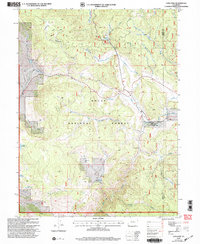
2000 Map of Lynx Pass
USGS Topo · Published 2004About this map
Lynx Pass sits at the heart of this high-elevation landscape within the Routt National Forest, where the complex drainage systems of the Morrison Divide define the local topography. This 2000 revision illustrates a remote area of the Colorado Rockies focused on water management and conservation, featuring several high-country catchments like Bulkley Reservoir, Hadley Reservoir, and Reid Reservoir. Near the pass, the presence of a Guard Sta and the Muddy Slide Trail indicates the active management and recreational access of the national forest land. Eastward, the Rock Creek State Wildlife Area provides a specialized habitat buffer, while evocative watercourse names like Shoe and Stocking Creek and Whiskey Creek reflect the heritage of early explorers and cattlemen who traversed these gulches and parks.
Find a feature on this map
31 named features on this map. Tap any name to fly to it.
Don’t see what you’re looking for? This feature index may not catch every label — zoom into the map to look around manually.
Map Details
Editions of this 2000 Lynx Pass Map
This is the sole edition of this map. No revisions or reprints were ever made.
Other maps of this area

1954 · Craig
USGS Topo · 1:250,000

1956 · Gore Pass
USGS Topo · 1:62,500

1957 · Craig
USGS Topo · 1:250,000

1957 · Leadville
USGS Topo · 1:250,000

1958 · Craig
USGS Topo · 1:250,000

1959 · Leadville
USGS Topo · 1:250,000

1960 · Leadville
USGS Topo · 1:250,000

1960 · Craig
USGS Topo · 1:250,000

1962 · Leadville
USGS Topo · 1:250,000

1962 · Craig
USGS Topo · 1:250,000