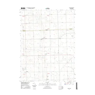
2016 Map of Lyons
USGS Topo · Published 2016About this map
The Michigan-Ohio border cuts through this landscape, dividing the agricultural lands of Lenawee and Fulton counties. The village of Lyons serves as a central hub, situated near the intersection of W Morenci St and Lyons Hwy. The region's drainage is defined by a series of meandering waterways, including Tenmile Creek and Bear Creek, which traverse the flat terrain alongside a rigid grid of rural roads like US Rte 20. For those tracing local history, several distinct burial grounds are noted, from the centrally located Lyons Cem to the outlying Edgar Cem and Rose Hill Cem. To the east, the Newbury Airport sits near Seward, while the southern reaches of the map include the small settlements of Advance and Winameg. This survey illustrates the persistent rural character of the borderlands, where family farms are bounded by township roads and small creeks.
Find a feature on this map
59 named features on this map. Tap any name to fly to it.
Don’t see what you’re looking for? This feature index may not catch every label — zoom into the map to look around manually.
Map Details
Editions of this 2016 Lyons Map
This is the sole edition of this map. No revisions or reprints were ever made.
Other maps of this area

1911 · Wauseon
USGS Topo · 1:62,500

1911 · Swanton
USGS Topo · 1:62,500

1913 · Wauseon
USGS Topo · 1:62,500

1914 · Swanton
USGS Topo · 1:62,500

1939 · Blissfield
USGS Topo · 1:62,500

1941 · Blissfield
USGS Topo · 1:62,500

1943 · Wauseon
USGS Topo · 1:62,500

1953 · Fort Wayne
USGS Topo · 1:250,000

1956 · Fort Wayne
USGS Topo · 1:250,000

1956 · Toledo
USGS Topo · 1:250,000