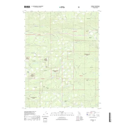
2018 Map of Lyonsville
USGS Topo · Published 2018About this map
Lyonsville anchors this survey of high-elevation terrain within the Lassen National Forest. The landscape is defined by a dense network of water systems, including Antelope Creek and its various forks, alongside family-named landmarks like Brazell Meadows and Howard Meadows. This area of Tehama County reveals a history of timber and utility access, evidenced by roads such as Little Giant Mill Rd and Tramway Rd.
Find a feature on this map
51 named features on this map. Tap any name to fly to it.
Don’t see what you’re looking for? This feature index may not catch every label — zoom into the map to look around manually.
Map Details
Editions of this 2018 Lyonsville Map
This is the sole edition of this map. No revisions or reprints were ever made.
Other maps of this area

1886 · Lassen Peak
USGS Topo · 1:250,000

1892 · Lassen Peak
USGS Topo · 1:250,000

1894 · Lassen Peak
USGS Topo · 1:250,000

1935 · Paynes Creek
USGS Topo · 1:96,000

1941 · Mineral
USGS Topo · 1:125,000
1953 · Panther Spring
USGS Topo · 1:62,500

1955 · Westwood
USGS Topo · 1:250,000

1956 · Lassen Peak
USGS Topo · 1:62,500

1956 · Manton
USGS Topo · 1:62,500

1958 · Westwood
USGS Topo · 1:250,000