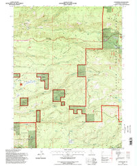
1995 Map of Lyonsville
USGS Topo · Published 1998About this map
Lyonsville and the surrounding timberlands of the Lassen National Forest define this 1995 revision of Northern California's volcanic landscape. The settlement pattern is characterized by seasonal and historic campsites such as Bells Camp (Site), Tent Camp (Site), and Camp Five (Site), reflecting the area's transition from early pioneer outposts to modern recreational and forestry use. The complex hydrology of the region is evident in the numerous water sources including Maidenhair Spring, Wible Spring, and Doty Spring, which feed into major drainages like South Fork Battle Creek and Antelope Creek. Private holdings like the Cline Ranch and the Battle Creek Rod & Gun Club are interspersed among public lands, while the presence of a Cem near the primary townsite offers a tangible link for genealogists tracing the early residents of this high-elevation mountain community.
Find a feature on this map
53 named features on this map. Tap any name to fly to it.
Don’t see what you’re looking for? This feature index may not catch every label — zoom into the map to look around manually.
Map Details
Editions of this 1995 Lyonsville Map
This is the sole edition of this map. No revisions or reprints were ever made.
Other maps of this area

1886 · Lassen Peak
USGS Topo · 1:250,000

1892 · Lassen Peak
USGS Topo · 1:250,000

1894 · Lassen Peak
USGS Topo · 1:250,000

1935 · Paynes Creek
USGS Topo · 1:96,000

1941 · Mineral
USGS Topo · 1:125,000
1953 · Panther Spring
USGS Topo · 1:62,500

1955 · Westwood
USGS Topo · 1:250,000

1956 · Lassen Peak
USGS Topo · 1:62,500

1956 · Manton
USGS Topo · 1:62,500

1958 · Westwood
USGS Topo · 1:250,000