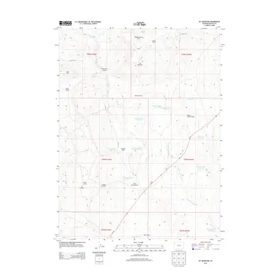
2013 Map of M F Mountain
USGS Topo · Published 2013About this map
M F Mountain and the high desert terrain of Moffat County define this section of the Colorado landscape as it appeared in the early 21st century. The drainage patterns of Wolf Creek and the Middle Fork Wolf Creek are the primary natural features, carving through landmarks such as Wolf Creek Canyon and Bear Canyon. Human activity is centered on ranching and water management, evidenced by the scattered network of reservoirs including Mancos Reservoir Number 1, Baking Powder Reservoir, and the Peterson Draw Reservoir 1. Remote outposts like Petes Post and the Bar 74 Ranch sit near expansive landforms like Maverick Flats and Baking Powder Ridge. This map illustrates a region where life is dictated by the availability of water, marked by numerous named springs such as Wild Horse Spring and Three Springs, and the seasonal flows of The Sloughs.
Find a feature on this map
38 named features on this map. Tap any name to fly to it.
Don’t see what you’re looking for? This feature index may not catch every label — zoom into the map to look around manually.
Map Details
Editions of this 2013 M F Mountain Map
This is the sole edition of this map. No revisions or reprints were ever made.
Other maps of this area

1907 · Rangely
USGS Topo · 1:125,000

1907 · White River
USGS Topo · 1:125,000

1910 · White River
USGS Topo · 1:125,000

1910 · Rangely
USGS Topo · 1:125,000

1954 · Vernal
USGS Topo · 1:250,000

1958 · Vernal
USGS Topo · 1:250,000

1960 · Vernal
USGS Topo · 1:250,000

1960 · Elk Springs
USGS Topo · 1:62,500

1962 · Cactus Reservoir
USGS Topo · 1:24,000
1962 · Divide Creek
USGS Topo · 1:24,000