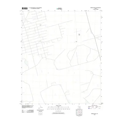
2010 Map of Mabee Ranch
USGS Topo · Published 2010About this map
Mabee Oil Field defines much of this landscape in Andrews County, where a dense grid of service roads and infrastructure points to the significant industrial footprint of petroleum extraction in West Texas. The property at Mabee Ranch serves as a central hub for the area, supported by its own private aviation facility at the Mabee Ranch Airport. This 2010 survey illustrates the systematic organization of a working ranch and oil field, with a network of unnamed access roads branching off from larger thoroughfares like Co Rd 3200. The spatial distribution of well sites and ranching operations reveals the specialized land use typical of the Permian Basin, where traditional livestock ranching and modern energy production exist side-by-side.
Find a feature on this map
4 named features on this map. Tap any name to fly to it.
Don’t see what you’re looking for? This feature index may not catch every label — zoom into the map to look around manually.
Map Details
Editions of this 2010 Mabee Ranch Map
This is the sole edition of this map. No revisions or reprints were ever made.
Other maps of this area

1954 · Hobbs
USGS Topo · 1:250,000

1958 · Hobbs
USGS Topo · 1:250,000

1965 · Northeast Midland
USGS Topo · 1:24,000

1966 · Mabee Ranch
USGS Topo · 1:24,000

1966 · Flynt Ranch
USGS Topo · 1:24,000

1966 · Bird Ranch
USGS Topo · 1:24,000

1966 · North Curtis Ranch
USGS Topo · 1:24,000

1966 · Northwest Midland
USGS Topo · 1:24,000

1968 · Baird Lake
USGS Topo · 1:24,000
1968 · Hackberry Lake
USGS Topo · 1:24,000