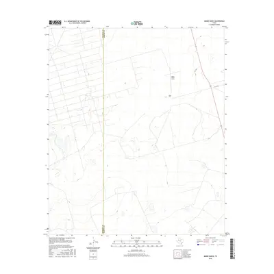
2016 Map of Mabee Ranch
USGS Topo · Published 2016About this map
Mabee Ranch and its namesake aviation facility, the Mabee Ranch Airport, anchor this 2016 survey along the arid borderlands of the Permian Basin. Situated on the county line dividing Andrews and Martin counties, the landscape is defined by vast tracts of open ranch land and a network of service roads. Local transit is facilitated by routes like Prc 3100 and Co Rd 3200, which provide access to the remote interior. The topography is typical of the high plains, characterized by subtle elevation shifts and scattered depressions that occasionally hold water. This map captures the modern footprint of a significant West Texas ranching operation, preserving the locations of private airstrips and rural infrastructure necessary for managing large-scale land holdings in this part of the state.
Find a feature on this map
5 named features on this map. Tap any name to fly to it.
Don’t see what you’re looking for? This feature index may not catch every label — zoom into the map to look around manually.
Map Details
Editions of this 2016 Mabee Ranch Map
This is the sole edition of this map. No revisions or reprints were ever made.
Other maps of this area

1954 · Hobbs
USGS Topo · 1:250,000

1958 · Hobbs
USGS Topo · 1:250,000

1965 · Northeast Midland
USGS Topo · 1:24,000

1966 · Mabee Ranch
USGS Topo · 1:24,000

1966 · Flynt Ranch
USGS Topo · 1:24,000

1966 · Bird Ranch
USGS Topo · 1:24,000

1966 · North Curtis Ranch
USGS Topo · 1:24,000

1966 · Northwest Midland
USGS Topo · 1:24,000

1968 · Baird Lake
USGS Topo · 1:24,000
1968 · Hackberry Lake
USGS Topo · 1:24,000