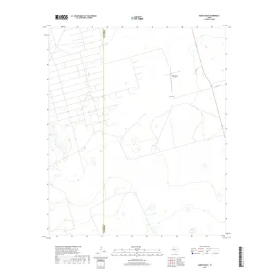
2019 Map of Mabee Ranch
USGS Topo · Published 2019About this map
The high plains of the Permian Basin define this landscape, where the long-standing Mabee Ranch serves as the primary landmark in a region defined by its wide-open ranching heritage. This 2019 survey captures the area as it straddles the county line between Andrews Co and Martin Co, illustrating a pattern of land use where sparse development is centered around private airfield access at the Mabee Ranch Airport. The terrain is navigated by a handful of established routes, including Co RD 3200 and PRC 3300, which cut through the level topography typical of this part of West Texas. For the researcher, the map documents the modern footprint of a significant regional ranching operation and the enduring isolation of the West Texas interior.
Find a feature on this map
5 named features on this map. Tap any name to fly to it.
Don’t see what you’re looking for? This feature index may not catch every label — zoom into the map to look around manually.
Map Details
Editions of this 2019 Mabee Ranch Map
This is the sole edition of this map. No revisions or reprints were ever made.
Other maps of this area

1954 · Hobbs
USGS Topo · 1:250,000

1958 · Hobbs
USGS Topo · 1:250,000

1965 · Northeast Midland
USGS Topo · 1:24,000

1966 · Mabee Ranch
USGS Topo · 1:24,000

1966 · Flynt Ranch
USGS Topo · 1:24,000

1966 · Bird Ranch
USGS Topo · 1:24,000

1966 · North Curtis Ranch
USGS Topo · 1:24,000

1966 · Northwest Midland
USGS Topo · 1:24,000

1968 · Baird Lake
USGS Topo · 1:24,000
1968 · Hackberry Lake
USGS Topo · 1:24,000