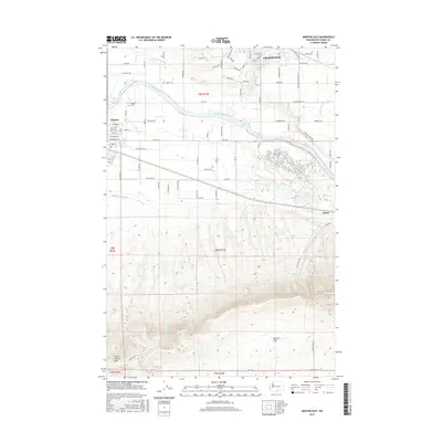
2017 Map of Mabton East
USGS Topo · Published 2017About this map
The Yakima River flows through a landscape defined by industrial-scale agriculture and sharp topographic shifts in this part of Yakima County. To the north, the developed grid of Grandview and the settlement of Mabton anchor the valley floor, supported by an intricate irrigation network including the Rocky Ford Lateral, Mathieson Lateral, and Mabton Feeder Lateral. This complex water system transforms the arid valley into productive farmland, as evidenced by road names like Apricot Rd, Chestnut Rd, and Walnut Ln. South of the river and the Byron settlement, the terrain rises dramatically into the Horse Heaven Hills. This southern portion of the map is characterized by steep contours and natural features like Cherry Spring and the elevated Missouri Flats, standing in contrast to the engineered irrigation of the lowland valley.
Find a feature on this map
85 named features on this map. Tap any name to fly to it.
Don’t see what you’re looking for? This feature index may not catch every label — zoom into the map to look around manually.
Map Details
Editions of this 2017 Mabton East Map
This is the sole edition of this map. No revisions or reprints were ever made.
Other maps of this area

1910 · Zillah
USGS Topo · 1:125,000

1915 · Prosser
USGS Topo · 1:125,000

1917 · Prosser
USGS Topo · 1:125,000

1950 · Yakima
USGS Topo · 1:250,000

1950 · Grandview
USGS Topo · 1:62,500

1951 · Grandview
USGS Topo · 1:62,500

1953 · Walla Walla
USGS Topo · 1:250,000

1955 · Prosser SW
USGS Topo · 1:24,000

1958 · Walla Walla
USGS Topo · 1:250,000

1958 · Yakima
USGS Topo · 1:250,000