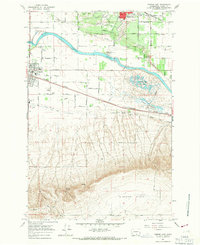
1965 Map of Mabton East
USGS Topo · Published 1967About this map
The Yakima River winds through this mid-1960s landscape, separating the agricultural grid of the Yakima Valley from the rising slopes of Missouri Flats. To the north, the irrigation infrastructure of Feeder Lat and various siphons supports an intensive farming district defined by orchard-lined roads like Cherry Ave and Apricot Rd. The Yakima Indian Reservation Boundary borders the town of Mabton, which serves as a local hub with its multiple schools, including Artz Sch and Fos Sch, and the Mabton Cemetery to the west.
Find a feature on this map
64 named features on this map. Tap any name to fly to it.
Don’t see what you’re looking for? This feature index may not catch every label — zoom into the map to look around manually.
Map Details
Editions of this 1965 Mabton East Map
This is the sole edition of this map. No revisions or reprints were ever made.
Other maps of this area

1910 · Zillah
USGS Topo · 1:125,000

1915 · Prosser
USGS Topo · 1:125,000

1917 · Prosser
USGS Topo · 1:125,000

1950 · Yakima
USGS Topo · 1:250,000

1950 · Grandview
USGS Topo · 1:62,500

1951 · Grandview
USGS Topo · 1:62,500

1953 · Walla Walla
USGS Topo · 1:250,000

1955 · Prosser SW
USGS Topo · 1:24,000

1958 · Walla Walla
USGS Topo · 1:250,000

1958 · Yakima
USGS Topo · 1:250,000