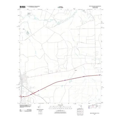
2011 Map of Macclenny East
USGS Topo · Published 2011About this map
The Saint Marys River winds along the northern boundary of this Florida-Georgia borderland, defining the landscape with its prominent curve at The Big Bend of Saint Marys River. The area is characterized by a low-lying, water-heavy terrain where Worley Lake and Shaw Lake sit just south of the main river channel. Small creek systems like Deep Creek, Turkey Creek, and Brandy Branch drain the piney flatlands, which are accessed by a network of rural roads such as St Marys Cove Rd and Steel Bridge Rd.
Find a feature on this map
27 named features on this map. Tap any name to fly to it.
Don’t see what you’re looking for? This feature index may not catch every label — zoom into the map to look around manually.
Map Details
Editions of this 2011 Macclenny East Map
This is the sole edition of this map. No revisions or reprints were ever made.
Other maps of this area

1917 · Cambon
USGS Topo · 1:62,500

1917 · Macclenny
USGS Topo · 1:62,500

1918 · Middleburg
USGS Topo · 1:62,500

1918 · Lawtey
USGS Topo · 1:62,500

1918 · Cambon
USGS Topo · 1:62,500

1918 · Macclenny
USGS Topo · 1:62,500

1941 · Middleburg
USGS Topo · 1:62,500

1948 · Jacksonville
USGS Topo · 1:250,000

1949 · Fiftone
USGS Topo · 1:24,000
1949 · Middleburg
USGS Topo · 1:62,500